NATIVE & COLONIAL
(1800’s)

ABOUT

Maps proclaim “This is here.”
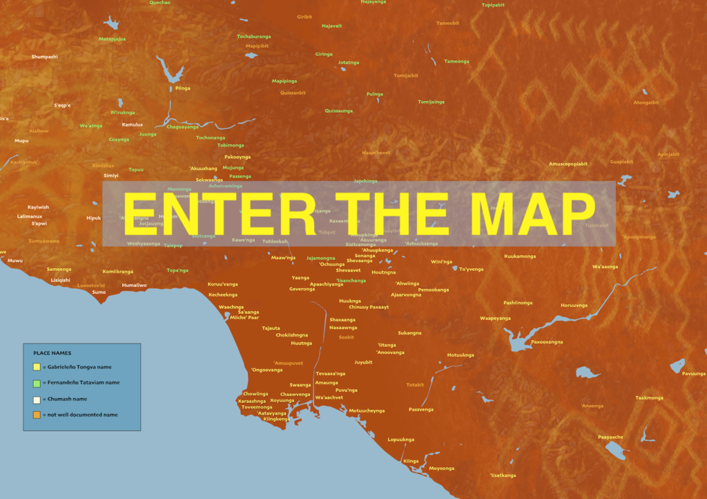
We overlay a conventional, contemporary map with one of Indigenous settlement names and provide an interactive slider so that viewers can make the connection between the two worldviews. Bringing together a variety of Native map sources, we can appreciate how richly populated the region was and the diversity of cultures that co-existed. Conveying a more fluid sense of territories, this map does not focus on pinpointing locations but rather affirms the names of places that have been here.
LA County is endowed with one of the largest urban Native populations in the United States. The local tribes are speaking for themselves and actively working for land justice and cultural thriving. We link to several below and encourage you to engage directly with them. We also include a map layer of Spanish and Mexican ranchos with another opacity slider to see how their land grant system overlays with the indigenous and has etched many of the place names that persist today.
EXPLORATION

      • Use the location search box to find places you are familiar with and explore which Indigenous settlements used to be located there.
      • Notice the pattern of settlements, their number, and their variety.  What can you learn from studying this pattern?
      • Which Native place names can you find still being used today? Why do some names persist and others disappear?
      • Which Spanish place names are still being used today?

NOTES

Mapping Indigenous land with conventional cartography has many contradictions. This map negotiates this tension in order to help make a bridge between mainstream maps to our collaborators’ alternative maps, which we encourage you to link to below.
Here we explain some of the cartographic choices we made. We intentionally do not pinpoint locations or outline borders of villages but rather write names on the landscape to acknowledge the completely different conceptions of territories and the fluidity of the livelihoods they support. Our legend identifies regional groupings of distinct villages with names based on the preferences of our partners. We use “Gabrieleño” and “Fernandeño” as categories that acknowledge the present day political groups’ connection to these two Spanish missions, which violently displaced and mixed groups and include people of different cultures and languages. We use “Chumash” which resists an identity based on the mission in Ventura and instead focuses on the linguistic connection between villages. We use an “*” to acknowledge that multiple groups claim a village. Our hope is that this map helps us imagine how we might decolonize the map.

ACKNOWLEDGMENTS

This map acknowledges that present day Los Angeles county is on the ancestral land of the Fernandeño Tataviam Band of Mission Indians,  Gabrieleño Band Of Mission Indians,  Gabrieleño Tongva Band of Mission Indians, Barbareño/Ventureño Band of Mission Indians.
Special thanks for collaboration and sharing of knowledge to:
Matthew Vestuto of the Barbareño/Ventureño Band of Mission Indians and his research including the website Chumash Placenames, Kimia Fatehi of the Fernandeño Tataviam Band of Mission Indians, Samantha Morales-Johnson of the Tongva Taraxat Paxaavxa Land Conservancy, Phil Ethington and the LA Landscape History Project team, and Native geography scholar Margaret Pearce.
We also appreciate the consultation of Tongva language scholar Pamela Munro’s collection of place names found in John Peabody Harrington’s papers, William McCawley’s The First Angelinos : the Gabrielino Indians of Los Angeles, Sally McLendon and John R. Johnson’s “Cultural Affiliation and Lineal Descent of Chumash Peoples,” Tongva People: a dynamic study of the Villages and Locations of the Gabrielino-Tongva Indians.
This map also offers an opacity slider of Gerald A. Eddy’s map “Old Spanish and Mexican Ranchos of Los Angeles County”, 1937 in order to see the subsequent Mexican colonization and land grants. Some of the land grants were given to the original native inhabitants, extending the tribe’s connection to the land. For example, you can view the map of land grants given to Fernandeño leaders here.
Slabbers who helped build this project: Scott Mahoy, Duo Bao, Temi Omotinugbon, Jiyoon Kim, Sihan Mao.
Financial support:  American Council of Learned Societies, USC Provost, USC Price School, USC Lusk Center for Real Estate.